THE MOUNTAIN
Mt Kalatungan, a.k.a Catatungan, is a volcanic mountain in Bukidnon, Northern Mindanao. PHIVOLCS has no recorded eruptions of this stratovolcano, yet classified potentially active. The mountain range stretches along the areas of Valencia, Maramag, Talakag and Pangantucan. The prominent summits are Kilakiron in Valencia and the twin Kalatungan and Lumpanag summits most accessible in Pangantucan.
 |
| The twin summits of Kalatungan (left) and Lumpanag (right) viewed north from Mt. Kitanglad summit. |
 |
| The twin summits Lumpanag (left) and Kalatungan (right) viewed south from Kalagutay Hills, Kalilangan, Bukidnon. |
 |
| The jump-off point at Barangay Mendis. |
 |
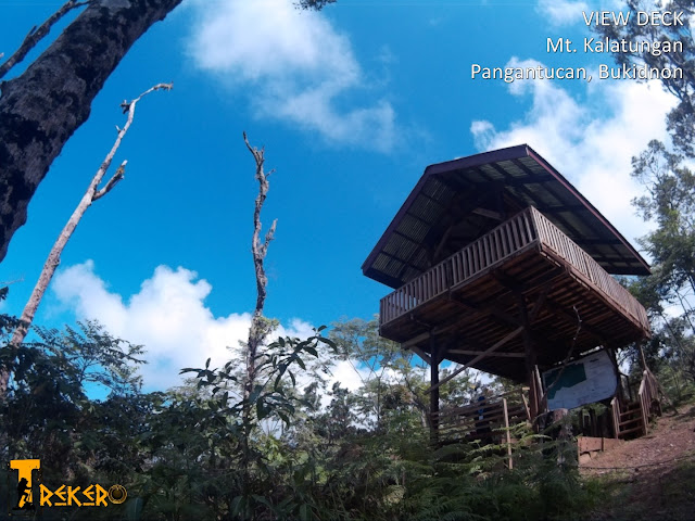
| The View Deck |
THE PHOTO BELOW SHOWS THE TOTAL DISTANCE TO TREK IN COMPLETING THE KALATUNGAN-LUMPANAG TRAVERSE...
 |
| Mountain Map and Distance Information Board at View Deck |
 |
| View of the lowloands including Lake Napalit. |
 |
| Muleta Falls graces the arduous Bukobuko sa Anay Trail. |
 |
| Muleta Falls |
 |
| The mossy forest of Mt. Kalatungan. |
 |
| The summit |
 |
| The long time dead bark at the summit is a favorite posing site of the climbers. |
 |
| The stunning view of Mt. Kitanglad Range. |
 |
| The offering site at the summit. Photo by Kleo Marlo R. Sialongo |
 |
| Boulders going to Lumpanag Summit from Kalatungan Summit. |
 |
| The boulders of Lumpanag (Wiji) Peak. |
 |
| Kalatungan Peak viewed from Lumpanag Peak. |
 |
| The awesome cliffs of Mt. Kalatungan Range. |
 |
| The common leech in Mt. Kalatungan. |
 |
| The different species of poison ivy to be cautious about. |
OTHER FEATURES OF THE MT. KALATUNGAN
Aside from its grandiose summit, this mountain is a host to challenging boulders, majestic waterfalls, hidden lakes, mossy forests, bonsai gardens and countless wonders.
Note: These spots cannot simply be reached by treading through the usual trail to the summit. These require separate treks.
 |
| The bonsai garden of Mt. Kalatungan. |
 |
| The Red Lake carefully hides within the forests of Mt. Kalatungan. |
 |
| The alluring Kaayatan Falls. |
 |
| The mighty Katakata Falls. |
 |
| Getting in touch with Katakata Falls. |
 |
| The spectrum of colors in Katakata Falls. |
 |
| The lady-like curvature of Sagayaran Falls. |
 |
| Didilusan Falls, my very first exploration site in Mt. Kalatungan. |
To view some more of the countless waterfalls, please click: Kalatungan Wonderfalls Album
CLIMB MANAGEMENT
In 2009, the LGU of Pangantucan, with PAMB-Kalatungan, crafted policies and ordinances governing the Entrance to Mt. Kalatungan Natural Park for well facilitated and coordinated visit to the mountain, giving due respect and importance to the rights and roles of our highlander brethren settled in the area. Pangantucan is now the registration center and the major entrance and jump-off to Kalatungan summit.
HOW TO GET THERE
From CDO, take a take a Rural Transit (Rural Tours, with Aircon) bus bound for Wao. Drop at Pangantucan. The trip is around 5 hours.
From Davao, take a Rural Transit (Rural Tours, with Aircon) bus bound for CDO. Drop at Maramag Terminal. The trip is around 3-4 hours. take a bus or van bound for Wao (Lanao del Sur) and drop at Pangantucan. The trip is around 45 minutes.
You may spend the night at Tourism Lodge (P250/night) or proceed directly to brgy. Mendis (jump-off) via habalhabal (P80 for a passenger with his baggage) and pitch a tent.
SCHEDULE OF FEES (As of August 2016)
Mountain Park Permit = P300/per head (payable to Tourism Office,
Municipal Hall)
Guide = P350/day (can carry a max 10kg load)
Porter = P400/day (max of 15 kg)
Plus white chicken, local wine (Fighter Wine), coins and fabric bits for RITUAL
No ritual fee required
No ritual fee required
THE CLIMB ITINERARY
We established the shortest and the easiest traverse trail,
that is 2days, instead of 3days.
It is always advised to start a climb early.
Always ask the guides for water sources.
Here's a typical IT for Kalatungan-Lumpanag (Wiji) Traverse:
Day1
7:00-7:30 - Poblacion to Brgy Mendis via habalhabal
7:30-7:45 - meet the guide and porter / give the chicken
7:45 - start trekking (with river/water source along the
way)
9:00 - ETA Viewdeck, with water source
10:30 - ETA Buko-buko sa Anay Ridge
11:30 - Lunch; rest; picture taking (Muleta Falls visible)
12:00-3:30 - Trek from Bukobuko sa Anay to the Summit
(with
last water source in between)
3:30-4:30 - At the Summit
4:30-5:30 - Descent to Dwarf Bamboo Camp (abundant water
source)
5:30 - Set up camp, cook, rest
Day2
6:30-7:30 - Prepare food, clear camp, water loading
7:30-8:30 - Ascent to Lumpanag Peak
8:30-9:00 - At the Summit; picture taking (Kitanglad Range
visible)
9:00-11:30 - Cross along 3 minor peaks
11:30 - Lunch
12:00-2:30 - Descent to brgy Mendis (it's not a backtrail)
2:30-3:00 - Tidy up, take habalhabal to Poblacion Terminal
3:00 - Take a bus direct to CDO
or take
a van to Maramag, then take a bus to Davao or Cotabato Area
For further queries, pls contact:
Christopher M. Diaz (that's me) - 0926-247-8796
For booking and permit concerns, pls directly contact:
Ms. Lea M. Apal (OIC Tourism Officer)- 0917-774-5868
For booking and permit concerns, pls directly contact:
Ms. Lea M. Apal (OIC Tourism Officer)- 0917-774-5868


Ang ganda! Parang nakakatempt i-try considering it's near from Davao. Thanks for this guide... and you have nice photos! :)
ReplyDeleteThanks, Gana. You will surely enjoy this mountain. Malapit lang naman to sa Davao...
DeleteLast 2012 I had my year-end climb at D2K... This year I am sched for Sumgaya-Lumot....
ReplyDeleteI wish I had stumbled on this entry earlier... Your photos captures the beauty of Mt. Kalatungan.... I guess my 2014 year end is already set here.
this beautiful mountain awaits for your footprints...
Deleteand sure you are really no empty.
Hi! This is a beautiful guide! I'll be making this as a basis for our Kalatungan Traverse :D
ReplyDeleteJust a question, we will also be doing a K-D2 next after this, possbile naman sa 4days IT right?
thanks, bro... that would be very hectic yet challenging schedule considering the distance from pangantucan to impasugong. besides, these are major mountains of the country.
Deleteby the way k-d2 traverse alone takes 3 days. but all the hardships and difficulties of these mountains are all worth the effort.
have safe and enjoyable climbs...
Hi.i just want to ask if the park is open? Whats the best time/month to climb? Thanks
ReplyDeleteas of now, may 30, 2016, there is no advice from LGU yet as to reopening of the park. hopefully, starting this rainy season, the mountain will be opened again.
Deletethe best month to climb is between october-april when you can view sunrise and sunset. but all year round, this mountain is always a great site for adventure.
How do we book a climb, how to get permit, get a guide and porter.It's unlike Apo where agents arrange a climb and trail to take. We would love to visit Bukidnon esp.every destination described in your blog. Awesome province.
DeleteFor booking and permit concerns, pls directly contact:
ReplyDeleteMr. Renato Sabado (Tourism Officer) - 0917-707-7805
Thank you for reading my blog. Visit Bukidnon and Enjoy.
http://visitbukidnon.blogspot.com/
Nice write ups... looking forward in meeting you there :D
ReplyDeletethank you.
Deletewould be glad to see you in the trails.
Sir may limit ba sa tao mg akyat? Or # of persons in group ilan po?
ReplyDeletehi, chaddy. to date, wala pang limit ang number of climbers within the day. it even caters up to 70 climbers during invitational events.
Deletehow long of a hike is it from the base to the summit? 3.6 kilometers?
ReplyDeletehi, grant. thanks for dropping by. the 3.6 km distance is only from jump-off ((mendis) to view deck. from jump-off to kalatungan peak is 8.85 kms. you may check the detailed distance from point to point at the photo above. visit the mountain soon...
Deletemalapit lang ba ang katakata falls from the summit of Kalatungan?
ReplyDeletemalayo ang katakata falls sa summit. it takes different route (via portulin). the closest falls to the summit is muleta falls; clearly visible from bukobuko sa anay ridge during clear days. by the way, if you climb kalatungan and have extra time, there are 2 falls accessible at jump-off, lisihon falls and migkaramagan falls. these can be trekked in a half day at fast pace.
Deletehi sir. good day. may query lang po sana ako and we think we need your opinion regarding the expenses. nag quote kasi yung guide namin ng package expenses to climb mt. kalatungan. 2k/head, is this still within the acceptable price range?? slamat for your time sir.
ReplyDeleteHi, unknown. Whether you're from cdo or davao, P2,000 per head is way more expensive. But since it's an organized climb, there's business in it and what you are paying for is CONVENIENCE.
DeleteDon't worry, you will really enjoy and it will be worth it.
Hey, I am a junior software developer situated at Pangantucan, Bukidnon. I would like to ask for permission to use some of your photos to feature in a gallery section of my proposed first Tourism Application for Pangantucan, Bukidnon.
ReplyDeleteHi! Yes, you may use my photos for tourism promotion purposes. Credits will be appreciated.
Deletehi sir,.i know this is a crazy question but we have a schedule climb tomorrow and right now im experiencing muscle soreness because of the preparation i made. would you recommend for me to continue? is it way harder than mt apo po?
ReplyDeleteHi, the mountain is truly challenging. Like any other mountain, we cannot underestimate Mt. Kalatungan. You know yourself better. If you feel you can make it given the condition, then go. But then Kalatungan is a major mountain. And it's harder than Mt. Apo. Plus you will traverse to Mt. Lumpanag. Going down also requires to cross many minor summits. And the weather this time is not favorable for climbing.
DeleteJust think of your safety. Anyway, the mountain is always there, waiting for a perfect moment for you to enjoy it.